Winter Wonderland Hyde Park London

From Winter Wonderland - London December 2008


Hyde Park's Winter Wonderland (official site here) runs from November 22nd to January 4th. Among the main attractions is the giant wheel, ice skating rink, German Winter market and a host of smaller funfare type rides.

The Observation Wheel gets you 200feet up, and a ride lasts about 13 minutes - we got 3 rotations. The weather was fairly good for us and we could see all the way to the Gherkin in the east.

From Winter Wonderland - London December 2008


You should probably book the ice skating in advance. We got to the ticket office at midday and the next slot was 7.45pm. Luckily we met someone who had surplus tickets.

In general I would say its not very good value. Rides are generally 3 tokens per child and 4 per adult, and each
token is £1. The ice skating is quite good value as you get about 1 hour on the ice.


Lake Tahoe

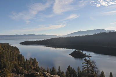
From Lake Tahoe Dec08
Lake Tahoe and its basin is the result of a geological fault which has caused the earth to slip vertically downwards between two mountain ranges, the Sierras to the west, and the Carson Range to the East. Initially the lake had a northern outflow, but volcanic activity blocked this outlet, and the water level rose. By the last ice age the water was approximately 800ft higher than today, which you can see when you arrive from the south because the southerly flat area is where they've built the airport.

Eventually the water level reached a level which allowed a new outlet, and this is the Truckee River, which initially flows north before wending its way east and into Nevada.

The average level of the lake is 6225 feet above sea level. During July 14-18 1907 the lake rose to its highest recorded level of 6,231.26 feet, while the lowest level on record is is 6220.26 feet on November 30, 1992. Today the maximum level is set by law and is 6229.1 feet. There is a dam at Tahoe City at 6223ft which sets the 'rim' of the lake.

As of Dec 2008 the level is 3ft above datum, the datum being 6220ft, so the water level is 6223ft above sea level, which means very little water is leaving via the Truckee River.

This page www.boattahoe.com/lakeleveldata.htm has water level history. When I was last there in July 2005 I can see the water was at about 5.5ft above datum, or 6225.5ft. This is a graph of 2005's level:

graph borrowed from above site, data from USGS. Heights are above datum (see above)

Facts and figures from Wikipedia:
Lake Tahoe is the second deepest lake in the United States, with a maximum depth of 1,645 feet (501 m), trailing only Oregon's Crater Lake at 1,949 ft (594 m). Tahoe is also the 16th deepest lake in the world, and the fifth deepest in average depth. It is about 22 mi (35 km) long, 12 mi (19 km) wide, 72 mi (116 km) of shoreline and a surface area of 191 square miles (490 km2).

A curious side effect of the water being so deep is that the bottom is actually 92ft below Carson City, but this will change because the lake is filling in. If it continues to fill in at the current rate of 1ft every 3200 years, then assuming the cessation of mountain building remains, the lake will become a meadow.

Sunrise at Lake Tahoe


Had a spare day, so went to Lake Tahoe. Decided to see in the sunrise.

By way of preparation I used www.timeanddate.com to see where the sun would rise in the sky. Then I used Google Earth to plot the azimuth ie where the sun would rise. When I was there it showed

Dec 7, 2008 7:12 AM 4:51 PM 118° 241°

So thats east south east, and if we were at sea level, and we could see the horizon, means the sun would appear at around 7.10am. As it happens the sun came from behind the mountain at 7.25am. And it was rather cold at about 27°F!